• 1
  • 2
  • 3
  • 4
  • 5
  • 6
  • 7
  • 8
  • Aerial photo after sunset of the City of Marina and all its city lights with the Fort Ord Dunes, Monterey Bay and Monterey Peninsula in the background.
    A single person walks alone on an expansive beach at sunset.
    Aerial drone photo of auntumn colored vineyard rows set against the Salinas River at sunset.
    Aerial photo from about 200 feet above a vineyard looking at the tasting room festivities with vineyards and mountains in the background.
    Aerial drone photo of expansive vineyards rows of autumn colors at the foothills of the Gabilan Mountains.
    Aerial drone photo of auntumn colored vineyard rows set against Pinnacles National Park with puffy clouds acattered across a blue sky.
    Drone photo of a city-block-size apartment complex near the beach and a pier.
    Abstract aerial drone photo looking directly down at colorful swirling patterns in the brackish water and foliage of a salt marsh.
    Aerial drone photo looking directly down at surf, rocky shore, turquoise sea, and kelp forest.
    Streaks of red, green and white light softly illuminate a vineyard at night.
    Aerial photo from about 50 feet above a River Road Wine Trail Valentines Passport festivities with vineyards and mountains in the background.
    Abstract black and white aerial drone photo looking directly down at crisscrossing field rows.
  • Streetscape of a roundabout intersection in a suburban neighborhood shot with a drone camera.
    Drone photo of a city-block-size apartment complex near the beach under construction.
    Streets, houses, apartments, and shopping centers go on endlessly. Shot with a drone camera.
    Drone photo of a West Santa Cruz neighborhood looking out over the Monterey Bay.
    Orange and purple sunset over a suburban neighborhood with tree silhouettes shot with a drone camera
    A man fishing on the beach at sunset shot with a drone camera.
    Abstract aerial drone photo looking directly down at colorful swirling patterns in the brackish water and foliage of a salt marsh.
    Abstract aerial drone photo looking directly down at colorful swirling patterns in the brackish water and foliage of a salt marsh.
    Looking down on green surf with a bird floating beyond the break.
    Drone photo of a West Santa Cruz neighborhood looking out over the Monterey Bay.
    Drone photo of a West Santa Cruz neighborhood looking out over the Monterey Bay.
    Aerial photo of a family walking along the water’s edge at sunset on the Monterey Bay.
  • Aerial photo looking north up the sand dunes and coastline of the Monterey Bay from a drone.
    Aerial photo of a solitary man walking along the water’s edge at sunset on the Monterey Bay.
    Medical facility shot from a drone.
    Drone photo of a park with library, trees, trails, and large pond sourounded by homes, san dunes, and the ocean.
    Aerial photo from a drone of Moss Landing on a sunny day.
    Village center shot from a drone includes apartments, theater, offices, park and art galleries.
    Village center shot from a drone includes apartments, theater, offices, park and art galleries.
    Village center shot from a drone includes apartments, theater, offices, park and art galleries.
    Village center shot from a drone includes apartments, theater, offices, park and art galleries.
    Monterey Bay suburbia from the air.
    Traffic circle on Crescent Avenue in Marina.
    Armstrong Ranch strawberry fields at sunset.
  • Armstrong Ranch, City of Marina, and Monterey Bay from a drone.
    Armstrong Ranch strawberry fields at dusk.
    Aerial photo of the ocean waves washing around rocks and over a kelp forest. Shot with a drone camera.
    Aerial photo of the ocean waves washing around rocks and over a kelp forest. Shot with a drone camera.
    Aerial photo of the ocean waves washing around rocks and over a kelp forest. Shot with a drone camera.
    Vernal Pond with trails around it and homes in the background set in an oak woodland.
    A cyclist in a a Fort Ord trail through oak woodland.
    Twilight over the City of Marina and Monterey Bay.
    A beach cityscape at sunset shot with a drone camera.
    A twilight sky and mountain peak are the backdrop for this quiet suburban neighborhood shot with a drone camera.
    Twilight over the City of Marina and Monterey Bay with the Monterey Peninsula in the background.
    Drone photo of a West Santa Cruz neighborhood looking out over the Monterey Bay.
  • Drone photo of a West Santa Cruz neighborhood looking out over the Monterey Bay.
    Armstrong Ranch, City of Marina, and Monterey Bay from a drone.
    Armstrong Ranch and City of Marina from a drone.
    Ranch land at sunset with oak trees, strawberry fields and water tank.
    Aerial photo of the ocean waves washing around rocks and over a kelp forest. Shot with a drone camera.
    Aerial photo of the ocean waves washing around rocks and over a kelp forest. Shot with a drone camera.
    Drone photo of sand dunes and the beach with trails winding through.
    Drone photo of a suburban park, roads and neighborhood.
    Panoramic aerial photo shot from a sUAS drone photo of the Arroyo Seco River and surrounding mountains and oak woodlands.
    Photo shot from a sUAS drone of the Arroyo Seco River gorge and surrounding mountains and oak woodlands with fall colors.
    Aerial photo of the Salinas River curving along the beach and sand dunes towards Moss Landing in the distance.
    Panoramic aerial photo shot from a sUAS drone photo along the Big Sur coast.
  • Abstract aerial drone photo looking directly down at colorful swirling patterns in the brackish water and foliage of a salt marsh with animal footprints in the mud.
    Looking directly down at a vernal Pond on the former Fort Ord.
    Aerial photo from about 300 feet above a River Road Wine Trail Valentines Passport festivities with vineyards and mountains in the background.
    Aerial photo from about 150 feet above a River Road Wine Trail Valentines Passport festivities with vineyards and mountains in the background.
    Aerial photo from about 200 feet above a River Road Wine Trail Valentines Passport festivities with vineyards and mountains in the background.
    Aerial photo from about 100 feet above a River Road Wine Trail Valentines Passport festivities with vineyards and mountains in the background.
    Aerial photo of track homes sourrounded by wilderness at sunset.
    Aerial photo from a drone aircraft of a car show in a park near a residential neighborhood with fram fields in the background.
    Aerial photo from a drone aircraft of a car show in a park near a residential neighborhood with fram fields in the background.
    Aerial drone photo of a hotel at the beach.
    Aerial photo from about 100 feet above a vineyard looking at the tasting room festivities with vineyards and mountains in the background.
  • Aerial photo of the ocean waves washing around rocks and over a kelp forest. Shot with a drone camera.
    Aerial photo of the ocean waves washing around rocks and over a kelp forest. Shot with a drone camera.
    Aerial photo shot from a sUAS drone photo looking south along the Big Sur coast.
    Sunset over the Monterey Bay with a neighborhood in the foreground shot with a drone camera.
    Aerial photo looking north up the sand dunes and coastline of the Monterey Bay from a drone.
    Abstract aerial drone photo looking directly down at colorful swirling patterns in the brackish water and foliage of a salt marsh.
    Aerial photo of a woman walking alone on the beach next to an emerald-colored ocean.
    Aerial drone photo of a summer vineyard bordering the Salinas River.
    Aerial drone photo of a spring vineyard along River Road in Steinbeck Country.
    Photo that shows the Big Sur coastline above the fog line.
    Aerial drone photo of cannabis garden.
    Aerial drone photo of cannabis garden.
  • Aerial drone photo of Turtle Creek Ranch.
    4 aerial drone photos of cannabis garden during different seasons..
    Aerial drone photo of Turtle Creek.
    Aerial drone photo of cannabis garden.
    Aerial drone photo of cannabis garden.
    Aerial drone photo of cannabis garden.
    Aerial drone photo of cannabis garden.
    Aerial drone photo of cannabis garden.

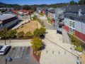
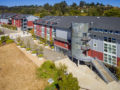
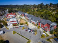
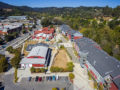
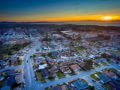
Don’t just hire a drone pilot, hire a photographer who knows how to fly. FAA Remote Pilot Certificate #4018318

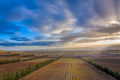
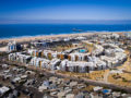
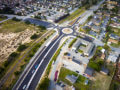
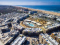
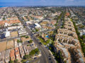
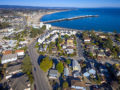
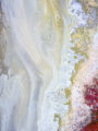
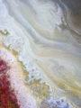
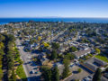
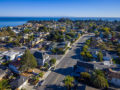
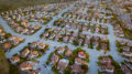
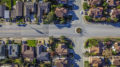
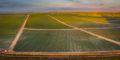
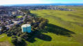
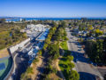
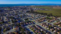
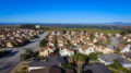
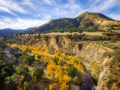
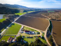
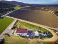
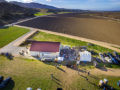
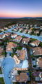
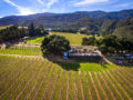
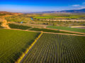
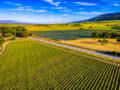
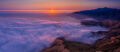
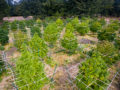
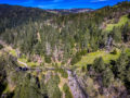
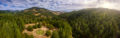
Steve Zmak is FAA certified to operate a sUAS/drone aircraft commercially. He has 20 years of experience photographing a variety of natural or developed terrain from a variety of aircraft and altitudes including fixed wing, helicopter, and unmanned/drone. He can portray the earth from the air very literally for urban planning and documentation, or more conceptually similar to portraiture, still life and landscape photography, or completely abstract with a painterly style. He has lectured on the subject of the artistry of drone photography at the Center for Photographic Art in Carmel, California.

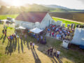
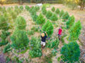
Every project is unique so call or email today for an estimate custom-tailored for your marketing, production or documentary needs. Drone flights for photography and/or video from $350.

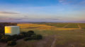
“I’m the kind of guy who is always glued to the airline window from take off to landing.  I love to fly and combining this with my love for photography shows through in the imagery.”

A man fishing on the beach at sunset shot with a drone camera.

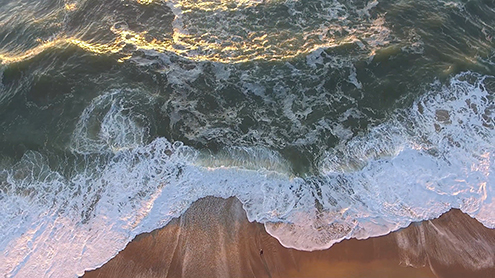
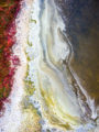
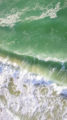
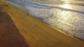
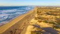
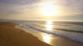
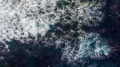
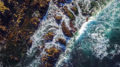
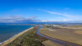
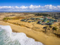
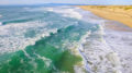
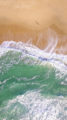
A lone fisherman standing on the edge of the world with wave shadows flickering like flames from the sunset. FAA certified sUAS/Drone photography.